The 2026 Grain Season – The majority of the Western Australian grain crop is in good condition at this stage of the season
Recent rain across much of the Western Australian grainbelt has freshened crops up following a particularly dry May period. Crops that had previously not emerged are now up and have a chance of achieving reasonable grain yields, with the warm soil temperatures helping crops bounce out of the ground. Rainfall across the majority of the grainbelt on 11th June has filled in the gaps from the previous rains in the last two weeks and will improve the outlook for those areas that received decent falls.
While based on global climate models, the forecast for a below average rainfall year and warmer than average spring temperatures remains, the current state of the grain crop in Western Australia is good. Crop growth stages across large areas of the grainbelt are more advanced than is often the case at this time of the year.
The Esperance port zone is in particularly good shape with one of the best starts to the growing season in recent history. Crops in the Geraldton port zone are also in good shape with large areas well ahead of where they have been in previous record tonnage years.
The Kwinana port zones are more mixed with some areas of early emerged crops looking good whilst areas in the central and southern portion of the zones are well down on year to date (YTD) rainfall. There is a poor strip in the southern portion of the Kwinana west zone running into the eastern Albany port zone that has continued to miss out on rainfall so far this year and will need a good run from now on to hit average yields. There is also a large strip of country from the bottom portion of the East Kwinana port zone down to the border of the eastern areas of the West Kwinana port zone and the eastern portion of the Albany port zone. This strip of late emerging crops is interspersed with smaller good strips that have had more YTD rainfall, however, some crops here are going to need some good falls of rain to hit average grain yields.
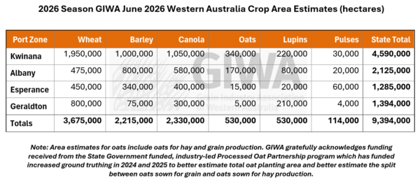
Countering the mixed condition of the crops in the central and southern regions, there is a very large crop area sown this year across the state, exceeding the previous record estimated area sown in 2025.
There has been a big swing out of wheat into canola this year due to the early rains favouring canola, which is the more profitable crop when planted in April and early May. Additional wheat area was also lost to barley driven by barley’s yield-by-price advantage over wheat during seeding. Growers in the low rainfall regions opted to continue planting rather than swap to fallow where they were able to follow moisture down in the profile in May. Earlier predictions of crop paddocks being left out due to the uncertainty of supply and cost of fertiliser and fuel have not eventuated.
The lupin area has not spiked as was predicted earlier in the year, but there has been an increase in pulse crop planting as was anticipated. However, the total area is very small relative to that planted to the major crop types. Oat area has also levelled out from 2025 due mainly to the forward price for oats destined for hay dropping below the previous year’s levels. The milling oat price has held up, and the traditional milling oat regions have similar planted areas to last year.
Whilst early sown crops will be buffered from the predicted drier and warmer year ahead if it eventuates, the very dry May has tended to use up a lot of the stored, subsoil moisture from pre-season rainfall, which will now not be there in the spring if needed.
Crops that have emerged are very clean having emerged through dry topsoil due to the dry May conditions. Emergence has generally been good and those paddocks that were a bit light on in numbers have now improved with rain over the last two weeks.
Overall, the state is set up for a reasonably good year if rainfall totals are at least close to average from now on.
Seasonal Outlook
Meredith Guthrie, Department of Primary Industries and Regional Development
Season Outlook June 2026
Climate summary
Rainfall from 1 April to 9 June saw Pemberton record the highest rainfall total of 282 mm, while Ongerup received only 14 mm (Figure 1). The fallow soil moisture map for 9 June indicates generally good soil moisture levels across the SWLD (Figure 2) following rainfall in early June, although conditions remain dry in parts of the Great Southern.
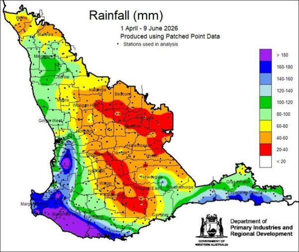
Figure 1 Rainfall from 1 April to 9 June 2026 for the South West Land Division (SWLD). Pemberton has the highest total of 282 mm and Ongerup has the lowest total of 14 mm.
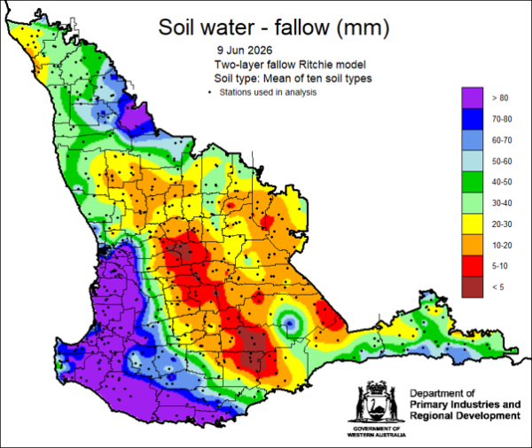
Figure 2 Plant available soil water map for the SWLD using rainfall up to 7 June 2026, uses the two-layer fallow Ritchie model and represents the mean of ten soil types. The map indicates generally good levels of soil moisture.
Forecast
The June to August (winter) rainfall outlook from the Climate Copernicus website, which combines nine global climate models including the ACCESS model from the Bureau of Meteorology, indicates that below-median rainfall is most likely across the SWLD (Figure 3). The skill of global climate models is generally good at this time of year.
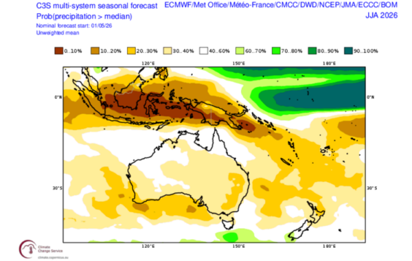
Figure 3 Probability of exceeding median rainfall for Australia in June to August (winter) 2026 from Climate Copernicus, which is a median of 9 climate models. Indicating below median rainfall is expected for the South West Land Division.
The current outlook indicates an El Niño developing in the Pacific Ocean during June, a potentially positive Indian Ocean Dipole developing in September, and an increased prevalence of high-pressure systems during winter. Together, these climate drivers are likely to reduce winter rainfall and bring higher temperatures across the SWLD.
Temperature
Both maximum and minimum temperatures for autumn (March to May) were average across the SWLD. Outlooks for maximum temperatures indicate that conditions are likely to be warmer than normal for winter (June to August). Minimum temperatures are also expected to be warmer than normal; however, frost will remain a risk due to the anticipated reduction in cloud cover.
Additional information is available from:
- DPIRD: Weather stations
- DPIRD: Soil Water Tool
- DPIRD Rainfall to Date Tool
- DPIRD Seasonal Climate Outlook newsletter
- BoM: Rainfall totals for cool season 2025/26
- BoM: Rainfall outlook for the next week
- BoM: Seasonal Rainfall Outlook
- BoM: Australian Water Outlook
Geraldton Zone
Even though the region had virtually no rain through May, growers continued to sow and follow the moisture down deep and this has really paid off this year with about 80 per cent of crops emerged prior to the showers in the last two weeks. The recent rain has brought the remainder of the sown country up which emerged very quickly due to the warm soil temperatures.
The newer varieties of wheat have substantially more vigour than varieties released just a few years ago and growers in the region have been quick to realise this and use this trait to their advantage. This practise change has already gained momentum over the last few years in other regions of the Western Australian grainbelt and even though the newer varieties do not necessarily have longer coleoptiles, this exceptional vigour has reduced the risk of chasing moisture deep when the outlook for rain is uncertain.
There was a big swing back into canola and lupins this year from the low areas planted in 2025 due to the late start to the 2025 season. Canola has handled the dry conditions well and many crops are now flowering. Even though the outlook for the remainder of the year is for below average rainfall and possibly a quick cut out to the season, crops are well placed to end up with good grain yields due to their early emergence.
Kwinana Zone
Kwinana North Midlands
The majority of crops sown into the medium to lighter soils were up before the recent rainfall events. Growers continued to sow and chase moisture deep, and the region did jag a few rains in May to help out with emergence. The heaver country has struggled until now, although most of these areas are now up and looking happier than they did a few weeks ago.
The potential for frost damage to wheat is a bit of a concern later in the year with these early sown crops, although most growers considered the risk worth taking as they are in with a chance if the crop is in the ground and up.
The early sown canola has been forced up into flower prematurely in some places, but growers have generally been quick to add nitrogen to effectively reset grain yield potential.
There has been a slight shift to more barley away from wheat. The legume area is up a little as well and the small but increased area of lentils look sensational and have handled the dry May conditions particularly well. Oat area is down quite a bit this year. Oats in the region are mostly grown for hay and as the hay price has come off a bit from last year, so has the area planted. All crops are very clean for weeds as most emerged through dry topsoil.
Pastures were good, then poor, but are now good again, having come to life following the recent rain. Growers that have held onto livestock have benefited from the surge in prices and are now well set for the winter.
Kwinana South
Crop condition in the zone is quite variable with some exceptional strips to the west, but some later emerging areas in the southwest from Quairading down to Narrogin. There are also strips that missed out on the heavier falls of rain that fell across the zone from the north-east to the south-east. Crops are up in these drier areas, but they are not really forging ahead as you would expect.
The increased canola area across the whole zone is looking very good, with excellent plant density and good cover resulting from the early planting opportunities. Canola crops are very clean for both weeds and disease. Only a few of the later-sown opportunistic canola paddocks are down on plant density.
The conundrum for growers at the moment is what to do with nitrogen applications as crops are going to need top-ups soon. While most of the crops are more advanced than normal, rainfall totals have been coming in at about half of what has been forecast and if this continues, crop grain yield potential will not match the potential growing season length. Rain over the next few weeks will be critical to keep crops on track for reasonable yields at harvest.
Kwinana North East
The Kwinana North East region in now looking good in the northern parts which received very good falls of rain recently. The southern areas have also picked up good falls, but not quite as much as those seen further north. The central northern areas, where crops went in early and received the good pre-season and early season rains, suffered from a very dry May. Although crops have picked up a bit recently, the draw on subsoil moisture may come back to bite them if the spring ends up being drier than normal.
There are some fantastic canola crops with very high grain yield potential for the region if they can get a couple of decent falls of rain in the next month.
There has been an increase in oat area in the region this year due to the opportunity for early planting more than anything else, with growers considering early planting of wheat to be too risky for frost.
The predicted fallow area did not materialise, with growers opting instead to plant cereals deep into available soil moisture.
There are some pockets of country that have missed out on both the pre-season rain and recent rainfall, although most of the region has all the planted area up now. Overall, the region ranges from very good to not so good as is often the case, with big areas reliant on some soaking rain in June and July to hit at least average yields.
Albany Zone
Albany West
Crops in the region are ticking along nicely with more crops going in earlier than is normally the case for the region. Crops are good in the western areas and fall away east of the Albany Highway, with the strip from Wickepin to Nyabing and down to Ongerup being one of the driest areas of the state. Conditions pick up closer to Jerramungup and closer to the eastern border of the Esperance port zone.
Crop establishment for canola and the cereals have been good, and crops have come through very clean for weeds. Growers were onto early knockdown sprays more than they have been in the past This looks like it may pay off if the predicted drier than average year eventuates, as the subsoil moisture is not ideal for the region.
The crop type mixture has not changed from last year apart from a slight continued shift into barley at the expense of wheat. The swap out of CAG canola has been occurring for a couple of years in the region although grass weed control has been a bit trickier due to the less-than-ideal spraying conditions when grass weed control timing was needed due to grass selective grass weed control treatments be more sensitive to environmental conditions at application compared to non-selective options with CAG canola varieties.
Albany South
In contrast to other areas of the state, canola emergence has been disappointing. Plant density is down on what is ideal and is amongst the worst for many years. There doesn’t seem to be any single explanation for this —it may simply have been due to the warm, drying condition during the early timing of seeding. In saying this, the early sowing has given most canola crops the chance to still hit average yields.
Barley crops look very good and will have high top end grain yield potential from the early planting.
The enterprise mix in the region has not changed significantly from last year as most are maxed out on canola area and barley is already the dominate cereal crop. Although there has been a swing into CAN canola due to recent favourable CAN prices on offer, and the newer CAN varieties being able to match the CAG varieties for grain yield.
It has been a particularly bad year for slugs, earwigs, slaters and weevils although crops are advanced enough now to not be at further risk.
Albany East (Lakes Region)
The Lakes region is variable with good early pre-season and more recent rain in the central portions of the zone, although the eastern and western fringes have missed out compared to other areas of the state with most receiving less than 20 mm in the last three weeks.
Crops are up, growing and more advanced than normal from the early sowing opportunity. There has been a subtle swing into more canola this year from this early planting opportunity and price advantage over the cereals. Oat plantings are similar to last year, however the dedicated hay growers have pulled back a bit on area due to the price levelling out at seeding time.
Esperance Zone
The Esperance region has continued to receive rain through May, and most crops were up by mid- to late May. The early canola crops are flowering and some of the cereals are advanced enough to be getting their first fungicide applications and nitrogen top-ups. The recent rain has been evenly distributed across the whole region, including the normally drier regions away from the coast. Many consider this to be one of the best starts to the season for the whole zone in recent memory. Crops are in very good shape right across the zone.
Fertiliser has been harder to source in the region than in some other parts of the state, so growers have used whatever they could access. Despite the excellent start, top-end grain yield potential may be capped by constrained nitrogen applications due to the sky-high nitrogen price.
Growers kept sowing through May and while a few forced themselves to slow down to give a spread of emergence dates for frost mitigation later in the year, most opted to continue and get the crop in relatively early. There has been a swing away from wheat with more canola and some more barley planted than in recent years. Pulse crops are up in the area from last year as well.
The usual pests are under control for the time being, with the snail areas and mice hot spots being baited, and areas of earwigs baited at seeding. There has been the usual Diamond Back Moth activity which is not causing any trouble at the moment and will be monitored in the spring.